


Michaux Lizard Map, Pennsylvania
Michaux Lizard Map, Pennsylvania
SKU:809368520232
Low stock: 1 left
Couldn't load pickup availability

Collapsible content
Description
ISBN 2023 Edition: 9798350711318
A real map for people who love real-world experiences.
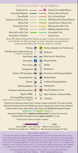
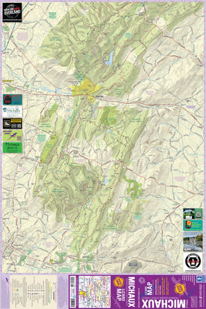
The 3rd Edition Michaux Lizard Map will help your customers plan all their adventures in and around Michaux State Forest. Adventures for all your customers. One of the most popular outdoor recreation playgrounds in Pennsylvania (12 million people live within a 100 mile radius of Michaux) Less than 3 hours from Philly, Pittsburgh, D.C., and Williamsport. 2 hours from Baltimore MD and State College, PA. A beautifully designed, easy to read topographic map featuring contour lines, elevation data, shaded relief, and all the key details your customers need to plan their adventures: backroads and trails, trail use designations, road surfaces (paved/gravel/4wd), parking access, campsites, public lands, historic sites and more. Lizard Maps are durable, waterproof, and give your customers the big picture – the map opens to 24” x 36” and folds easily to 4” x 8” to fit in a back pocket. The scale is 1:37,270 (1.7 inches = 1 mile). Includes both lat./lon. and UTM coordinate systems. Public land: all of Michaux State Forest (over 85,000 acres), Caledonia, Mont Alto, and Pine Grove Furnace State Parks and the Kings Gap Environmental Center. Destinations: the Appalachian Trail Museum, which is considered the symbolic halfway point of the AT, historic iron furnaces and an ironmaster’s mansion, the mansion at King’s Gap, and the historic Camp Michaux, a former secret WWII POW interrogation camp. Roads: all Lizard Maps show which roads are paved, dirt/gravel or 4wd roads as well as which are gated. Perfect for bicyclists, dual sport riders and overlanders looking to put together a remote backcountry route across public lands. Major hiking trails: the Appalachian Trail (AT) as it traverses Michaux State Forest, the trails at King’s Gap, the Flat Rock Trail System, and Rocky Knob Interpretive Trail. Major biking trails: Michaux is renowned for its advanced mountain bike trails featuring technical singletrack, steep climbs and steeper descents. The Michaux Lizard Map includes all of the DCNR officially recognized shared use trails at time of publication. Even more trails: Lizard Maps highlight and designate public trails and paths including hiking, biking, equestrian, skiing and rail trails managed by federal, state and local authorities, including the Mount Hope equestrian trail system. Michaux has an extensive ATV trail system. Points of interest: campgrounds, picnic areas, climbing areas, reservable car camping sites, scenic overlooks, observation towers and lizard spots. Natural Areas and special designated areas: include Meeting of the Pines Natural Area, Strawberry Hill Nature Preserve, Mount Holly Marsh Preserve, Carbaugh Reservoir, Waynesboro Reservoir, Long Pine Run Reservoir, and the Forest Pool Reserve (Nature Conservancy). Towns: Biglerville, Mont Alto, Mount Holly Springs, Shippensburg, and Waynesboro PA. Lizards! The little purple Lizards your customers will find scattered on the map signify an interesting spot to check out. The Legend says “This Could Mean Anything: cool place, sweet view, local legend”.